
from Aztec Minerals Corp. (CVE:AZT)
Aztec Drills 1.08 gpt Au and 30.23 gpt Ag (1.63 gpt AuEq) over 155.4 meters, Expands Oxide Gold-Silver Zone at Tombstone Project, Arizona
Step-Out Drilling Continues to Expand the Contention Zone of Oxide Au/Ag Mineralization along Strike and at Depth
Drill holes TR26-20 to TR26-30 have encountered multiple mineralized zones including an intersection of 155.4 m averaging 1.08 gpt Au and 30.23 gpt Ag (1.63 gpt AuEq) within 198.1 m averaging 0.86 gpt Au and 24.52 gpt Ag (1.30 gpt AuEq) in the Contention target area and other intersections on first pass test holes in the southwest and south of the Tombstone Property
VANCOUVER, BC / ACCESS Newswire / July 15, 2026 / Aztec Minerals Corp. (TSXV:AZT)(OTCQB:AZZTF) ("Aztec" or the "Company") announces the results from 11 drill holes (TR26-20 to TR26-30) from its reverse circulation ("RC") portion of the 2025-2026 drilling program at the Tombstone Property in Southeastern Arizona. Step-out and first pass drilling has extended mineralization to the west, southwest and south of previously reported holes, and drilling in the central Contention area confirmed broad continuity of the mineralized zone and extended the oxide mineralization significantly to depth.
Aztec Minerals CEO Simon Dyakowski commented: "Our expanded drill program continues to demonstrate significant growth of the near-surface oxide gold-silver mineralized zone at Tombstone. We are now aggressively testing the North End area target. Drilling in the Contention zone continues to demonstrate consistently strong oxide gold and silver grades at shallow depths. The most recent drilling of the 21,000 meter 2025-2026 program has been successful in significantly expanding the Contention oxide mineralization vertically to depth as well as identifying new targets at Hard Up and Independence, immediately to the west, and at East Grand Central within the property."
Highlights from the RC drilling reported for the Tombstone Property include:
Hole TR26-30 intersected 198.1 m averaging 0.86 gpt Au and 24.52 gpt Ag (1.30 gpt AuEq) from surface to 198.1 m, approximately 98% of the drilled length, including 155.4 m averaging 1.08 gpt Au and 30.23 gpt Ag (1.63 gpt AuEq) from 6.1 m, which includes 44.2 m averaging 1.50 gpt Au and 60.51 gpt Ag (2.60 gpt AuEq) from 56.4 m and 6.1 m averaging 9.54 gpt Au and 35.03 gpt Ag (10.18 gpt AuEq) from 121.9 m.
TR26-30 was collared in the central portion of the Contention pit adjacent to TR21-20 and fanned below it at -70 to a depth of 201.2m, and 45m east of TR21-17, reaching over 85m deeper vertically than TR21-20. The mineralized zone, hosted in hornfels, hydrothermal breccias and quartzites cut by quartz feldspar porphyry dikes, demonstrates continuity of oxidized mineralization between those holes and extends it vertically to depth in this portion of the Contention mineralization by 85 m, more than doubling the previously demonstrated depth.
Hole TR26-21 in the Independence Mine Target Area intersected 18.3 m averaging 0.05 gpt Au and 19.03 gpt Ag (0.39 gpt AuEq) from 18.3 m, including 4.6 m of 58.60 gpt Ag from 19.8 m.
Also at the Independence Mine, TR26-20 intersected 21.3 m averaging 0.08 gpt Au and 9.04 gpt Ag (0.24 gpt AuEq) from 51.8 m, including 4.6 m of 23.37 gpt Ag. Together these holes step out up to approximately 300 m west of previously reported drilling.
Hole TR26-28 was collared in the southern portion of the Contention pit, just east of the Grand Central pit, 50m east-southeast from TR25-32. It was drilled at 196 Az, -70 to test observed surface mineralization. The drill hole intersected three zones in the quartzites and hornfels, the strongest being 19.8 m averaging 0.20 gpt Au and 20.28 gpt Ag (0.57 gpt AuEq) from 199.6 m, including 10.7 m averaging 0.34 gpt Au and 33.50 gpt Ag (0.95 gpt AuEq) from 208.7 m.
Higher and adjacent in the drill hole, TR26-28 intersected 35.1 m averaging 0.04 gpt Au and 5.33 gpt Ag (0.13 gpt AuEq) from 155.4 m, and below at 239.3 m, 3.0 m averaging 0.05 gpt Au and 4.1 gpt Ag (0.13 gpt AuEq). This mineralization could lead to a larger discovery on the east side of the Contention zone.
Hole TR26-23 in the Hard Up area to the southwest intersected 22.9 m averaging 0.13 gpt Au and 13.04 gpt Ag (0.37 gpt AuEq) from 16.8 m.
Hole TR26-26 was collared in the southern portion of the Contention pit, just east of the Grand Central pit, 100m east-southeast from the South Spoke. It was drilled at 276 Az, -65 to test observed surface mineralization. The drill hole intersected two zones in the quartzites and hornfels, the strongest being 10.6 m averaging 0.34 gpt Au and 19.36 gpt Ag (0.70 gpt AuEq) from 125.0 m. Higher in the drill hole, TR26-26 intersected 4.5 m averaging 0.16 gpt Au and 18.2 gpt Ag (0.49 gpt AuEq) from 13.7 m.
The Company also reports the first assay results from the core drilling program: core holes TC25-01, TC25-02, TC25-03 and TC25-04:
First core program results: core hole TC25-03 returned two zones of CRD sulfide mineralization: 4.6 m averaging 0.16 gpt AuEq, 0.44% Pb and 0.28% Zn from 379.5 m, and 4.6 m averaging 0.69 gpt AuEq, 0.21% Pb and 0.02% Zn from 545.6 m at the historic T-8 CRD target horizon. TC25-04 returned 32.0 m averaging 0.26 gpt AuEq from 336.8 m within the retrograde skarn zone, including 3.0 m averaging 0.58% Pb and 35.50 gpt Ag (see Table 1A).
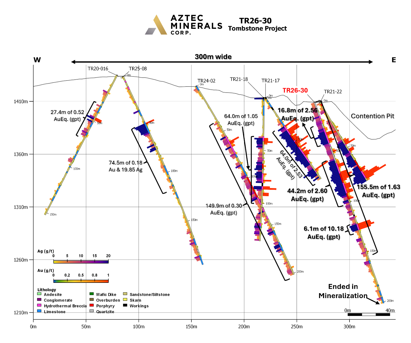
Figure 1. Cross section of RC drill hole TR26-30 showing Au and Ag assay results.
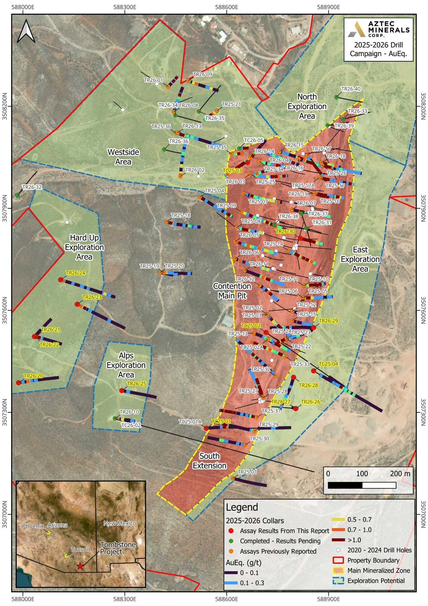
Figure 2. Plan map showing drill hole collars from the 2025-2026 drill campaign at the Tombstone Property, southeastern Arizona.
View drill sections here:
Link to section view hole TR26-20
Link to section view hole TR26-21
Link to section view hole TR26-22
Link to section view hole TR26-23
Link to section view hole TR26-24
Link to section view hole TR26-26 & TR26-27
Link to section view hole TR26-28
Link to section view hole TR26-29
Link to section view hole TR26-30
Table 1A: Drill Results Currently Reported
Drill Hole | From (m) | To (m) | Interval (m)* | Au (gpt) | Ag (gpt) | AuEq (gpt) | Comments |
|---|---|---|---|---|---|---|---|
TR26-20 | 51.8 | 73.1 | 21.3 | 0.08 | 9.04 | 0.24 | Independence Mine |
Including | 51.8 | 56.4 | 4.6 | 0.24 | 23.37 | 0.67 | |
and | 94.5 | 100.6 | 6.1 | 0.03 | 7.98 | 0.18 | |
TR26-21 | 18.3 | 36.6 | 18.3 | 0.05 | 19.03 | 0.39 | Independence Mine |
Including | 19.8 | 24.4 | 4.6 | 0.06 | 58.60 | 1.13 | |
TR26-22 | 0.0 | 4.6 | 4.6 | 0.09 | 4.23 | 0.17 | Independence Mine |
and | 44.2 | 48.8 | 4.6 | 0.08 | 4.67 | 0.16 | |
TR26-23 | 16.8 | 39.7 | 22.9 | 0.13 | 13.04 | 0.37 | Hard Up |
and | 59.4 | 64.0 | 4.6 | 0.04 | 3.73 | 0.10 | |
and | 147.8 | 150.8 | 3.0 | 0.12 | 1.70 | 0.15 | |
TR26-24 | 12.2 | 19.8 | 7.6 | 0.06 | 15.46 | 0.34 | Hard Up |
and | 114.3 | 121.9 | 7.6 | 0.07 | 6.12 | 0.18 | |
and | 242.3 | 257.5 | 15.2 | 0.04 | 7.86 | 0.18 | |
and | 275.8 | 278.8 | 3.0 | 0.16 | 1.85 | 0.19 | |
TR26-25 | No results with values of interest | ||||||
TR26-26 | 13.7 | 18.3 | 4.6 | 0.16 | 18.2 | 0.49 | East side Grand Central Pit |
and | 125.0 | 135.6 | 10.6 | 0.34 | 19.36 | 0.70 | |
TR26-27 | No results with values of interest | ||||||
TR26-28 | 155.4 | 190.5 | 35.1 | 0.04 | 5.33 | 0.13 | East side Grand Central Pit |
and | 199.6 | 219.4 | 19.8 | 0.20 | 20.28 | 0.57 | |
Including | 208.8 | 219.4 | 10.7 | 0.34 | 33.50 | 0.95 | |
and | 239.3 | 242.3 | 3.0 | 0.05 | 4.10 | 0.13 | |
TR26-29 | 131.1 | 160.1 | 29.0 | 0.10 | 8.84 | 0.26 | Eastern side of the Little Joe area |
Including | 144.8 | 149.4 | 4.6 | 0.44 | 28.10 | 0.95 | |
and | 175.3 | 179.9 | 4.6 | 0.14 | 8.60 | 0.30 | |
TR26-30 | 0.0 | 198.1 | 198.1 | 0.86 | 24.52 | 1.30 | Working @ 112.8-114.3 m, no sample; 1.5 m excluded from interval |
Including | 6.1 | 161.5 | 155.4 | 1.08 | 30.23 | 1.63 | |
Including | 24.4 | 41.2 | 16.8 | 1.51 | 58.04 | 2.56 | |
Including | 56.4 | 100.6 | 44.2 | 1.50 | 60.51 | 2.60 | |