from Aztec Minerals Corp. (CVE:AZT)
Aztec Drilling Expands Oxide Gold-Silver Zone at Tombstone Project, Arizona; intersecting 0.62 gpt Au and 24.8 gpt Ag over 107.9m in Westside Area and 0.48 gpt Au and 12.6 gpt Ag over 112.5m at Contention Area
Step-Out Drilling Continues to Expand the Contention and Westside zones of Oxide Au/Ag Mineralization
Drill holes TR26-1, 2, 8, 9, 13 and 14 encountered multiple mineralized zones expanding the Westside Anticline and Center target areas including an intersection of 107.9m averaging 0.62 gpt Au and 24.8 gpt Ag
Drill holes TR26-3, 4, 5, 6, 7, 11 and 12 expand the Contention Main target area to the west and depth, with multiple mineralized zones including an intersection of 112.5m averaging 0.48 gpt Au and 12.6 gptAg
59 RC holes including 5 pre-collars have now been drilled in the 2025-2026 drill program with 9 drill holes pending final analysis as the drilling campaign continues
VANCOUVER, BC / ACCESS Newswire / April 15, 2026 / Aztec Minerals Corp. (TSXV:AZT)(OTCQB:AZZTF) ("Aztec" or the "Company") announces the results from 14 drill holes from its reverse circulation ("RC") portion of the 2025-2026 drilling program at the Tombstone Property in Southeastern Arizona. Step out drilling in the Westside target area of the property has discovered additional strong, wide, shallow oxide gold-silver intersections. The mineralized zone has been further extended to 0.4km of width into the Westside area, with the Contention Au/Ag zone from the northern property limit to over 1km N-S on strike. Pending drill results include additional Westside area drill targets as well as several step out targets drilled in the immediate, westerly and deeper extensions of the Main Contention zone. The 17,000m 2025-2026 drilling program has now completed 59 RC and 6 core drill holes.
Highlights from the RC drilling reported for the Contention and the Westside targets include:
Hole TR26-14 encountered multiple zones of oxide mineralization in the Bisbee sediments, including 10.6m averaging 0.195 gpt Au and 13.0 gpt Ag from surface, 107.9m averaging 0.618 gpt Au and 24.8 gpt Ag from 39.5m, 48.6m averaging 0.091 gpt Au and 8.106 gpt Ag from 176.3m, and ending in 9.1m averaging 0.121 gpt Au and 10.17 gpt Ag from 234.1m. TR26-14 demonstrated that the entire width of the Westside anticline has potential to host oxidized precious metal mineralization. TR26-14 drilled across the upper portion of the Westside anticline towards the southwest from north of TC25-03.
Hole TR26-01 drilled to test the Westside anticline. The drill hole intersected at depth two zones of oxidized mineralization with historic mine workings, from 51.7m to 74.5m depth for 22.8m averaging 0.038 gpt Au and 11.87 gpt Ag and then from 86.6 m to 110.9 m for 24.3 meters averaging 0.039 gpt Au and 13.37 gpt Ag. TR26-01 demonstrated the location of the historic Westside mine workings and the surrounding area of low grade, oxidized precious metal mineralization in the Westside anticline.
Holes TR26-05 and TR26-06 are collared on the western limits of the central Contention area, drilling towards the east to test the western limits and to depth the Contention mineralization. The drill holes intersected multiple zones of mineralization, TD'd in mineralization at over 250m depth and have confirmed the Contention mineralization continues to depth and that it has expansive widths. The intersections include in TR26-05 50.2m averaging 0.112 gpt Au and 4.90 gpt Ag and in TR26-06 59.3m averaging 0.104 gpt Au and 4.96 gpt Ag
Hole TR26-07 is collared in the central portion of the Contention mineralization and expanded it to 239.3m depth intercepting three mineralized zones, including 112.5m averaging 0.479 gpt Au and 12.64 gpt Ag
Holes TR26-11 and TR26-12 are collared in western limits of the central Contention area, drilling towards the east to test the western limits and to depth the Contention mineralization. Combined they expanded the Contention Target mineralization 50 to 70 meters further west and to depth. TR26-11 intercepting 100.3m averaging 0.173 gpt Au and 11.46 gpt Ag and in TR26-12 intercepting 48.6m averaging 0.172 gpt Au and 18.04 gpt Ag.
All of the fourteen RC drillholes reported herein intersected Au-Ag mineralization and joined portions of and also expanded the Contention and Westside target areas to the west and to depth. The intercepts show broad continuity of mineralization. All reported intersection lengths are apparent widths of mineralization, not true widths, which can range at the property from 30% to 100% of apparent widths.
Aztec Minerals CEO Simon Dyakowski commented: "Our expanded drill program continues to demonstrate the potential for significant growth of the near-surface oxide gold-silver mineralized zone at Tombstone. We are now aggressively and successfully testing the Westside area target. Drilling in the Contention zone continues to demonstrate consistently strong oxide gold and silver grades at shallow depths. The 17,000 meter 2025-2026 program is currently following up on Westside area targets, and testing newly generated targets in the Southwest of the property which include the Ingersoll, Hard-up, and Independence targets. These new targets represent the potential to reframe the project to an even larger scale with shallow targets in areas over 1km away from the historic open pit operations."
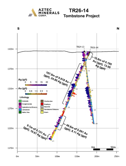
Figure 1. Cross section of RC drill hole TR26-14 showing Au and Ag assay results.
Tombstone 2025-2026 Drilling Plan Completed and Pending
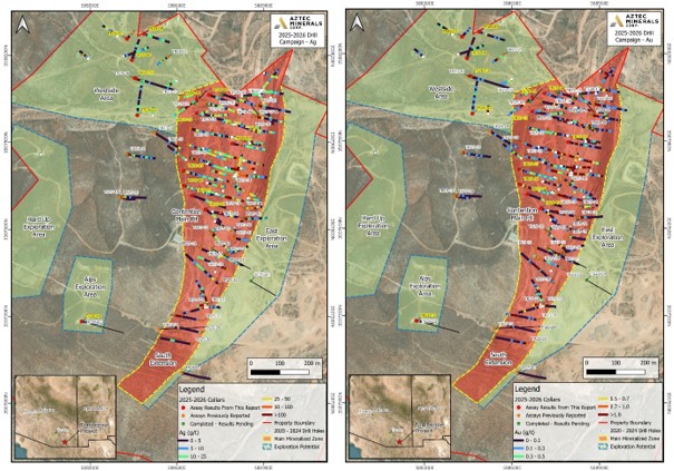
Figure 2 & 3. Plan maps showing drill hole collars from the 2025-2026 drill campaign at the Tombstone Property, southeastern Arizona.
Core Drilling Update
The core drilling portion of the program in 2026 continues with drilling ongoing in the 7th attempted core hole in the program TC26-03 targeting the central portion of the Contention mineralization of the property. Drill hole TC25-04 targeting the large, southern NSAMT target was recently completed at 831.7 m depth; however, was terminated by drillhole caving above the planned total depth of 1000m. TC25-04 encountered mild to moderate strength retrograde exoskarns in the hornfels of the lower Cretaceous basal Bisbee siliciclastic sediments at 575 m depth and it continued for the rest of the drillhole. The skarns are typified by epidote and chlorite with associated hematite staining. The skarns are accompanied by several silicified hydrothermal breccia dikes with occasional Qfp clasts and with evidence of potential "B-type" porphyry veinlets over that thickness. The skarns are notably more competent rock than the hornfels. The underlying Paleozoic Naco Formation limestones were encountered at 783.8 m depth in TC25-04.
Core drilling to-date has confirmed the NSAMT target as based on a geologic (Skarn) anomaly within the upper portion of the NSAMT target. It was planned to continue drilling to depth in TC25-04; however, drillhole caving terminated the hole. The core rig was then moved to drill TC26-01 to test to the west and below of TR21-12 but due to poor ground conditions and the completion of the RC precollar for TC26-02 the core rig was moved onto TC26-02 and it was completed at 861.9 m depth to test the southwestern NSAMT target. TC26-02 has intercepted skarning and sulfides recently as well. Aztec has previously identified several large, strong, conductive bodies, underneath the historic gold-silver district through NSAMT (natural-source audio-frequency magneto-telluric surveys) anomalies1.
The continued, successful drilling of the Contention pit area was supported by Aztec's 3D geologic and underground workings model that was constructed to assist in targeting potential expansion of the Contention system. The overall Contention system has yet to be defined and marks the confluence of other mineralized zones including the Westside Anticline.
Detailed Drillhole Summary Highlights (see Table 1 & 2 below):
Hole TR26-01 - Collared above the northwestern portion of the Westside anticline to test across the anticline. It was drilled northeasterly and to a depth of 117.4 meters. The drill hole intersected at depth two zones of oxidized mineralization, from 51.7m to 72.9m depth for 22.8m averaging 0.038 gpt Au and 11.87 gpt Ag and then from 86.6m to 110.9m for 24.3 meters averaging 0.039 gpt Au and 13.37 gpt Ag. The drillhole intersected mine workings at 71.5-73 m (Historic 2nd level) and at ended at 111-117m (Historic 4th level stope). TR26-01 demonstrated the location of the historic Westside mine workings and the surrounding area of low grade, oxidized precious metal mineralization in the Westside anticline. The drillhole leaves the mineralization open to depth and all compass directions.
Hole TR26-02 - Was collared west of TR25-08 in the central portion of the Westside Target area to test for mineralization related to the Center stope's anticline. It was drilled northerly and to a depth of 231 meters. The drill hole intersected four zones of oxidized mineralization including the highest one from the surface expanding the mineralization found in TR25-08. The intersections are: 0-19.8m, 19.8m averaging 0.136 gpt Au and 12.62 gpt Ag; 54.7-60.8m, 6.1m averaging 0.088 gpt Au and 13.67 gpt Ag; 91.2-100.3m, 9.1 m averaging 0.0.94 gpt Au and 5.65 gpt Ag; and 130.7-147.4m, 16.7m averaging 0.076 gpt Au and 2.76 gpt Ag. Drillhole leaves the mineralization open in all directions.
Hole TR26-03 - Collared in the northern portion of the Property where the Contention and Westside mineralization zones broadly join. Drilled as a high angle fan to TR25-25 to step out the mineralization to the west and to depth. Drilled to 274.4m depth, it has three mineralized zones in its lower half. The intersections are: 147.4-161.1m, 13.7m averaging 0.069 gpt Au and 3.73 gptAg; 167.2-177.8m, 10.6m averaging 0.103 gpt Au and 7.21 gpt Ag; and 193-205.2m, 12.2 m averaging 0.149 gpt Au and 8.7 gpt Ag. The drillhole leaves the mineralization open to depth and to the west, south and north.
Hole TR26-04 - Collared in the Westside area, north of TC25-34 drilling towards the east to test the junction of the Westside Anticline and Contention mineralization. It was drilled to a depth of 207.3 meters. The drill hole intersected three zones of oxidized mineralization. The intersections are: 53.2-63.8m, 10.6m averaging 0.057 gpt Au and 8.17 gpt Ag, 147.4-161.4m, 13.7 m averaging 0.040 gpt Au and 4.16 gpt Ag, and 168.7-188.5m, 19.8 m averaging 0.220 gpt Au and 13.75 gpt Ag. The drillhole ends near mineralization and leaves mineralization open to depth and to the west, east, south and north.
Hole TR26-05 - Collared in the western limits of the central Contention area, south of TC25-08, drilling towards the east to test the western limits and to depth the Contention mineralization. It was drilled to a depth of 256.1 meters. The drill hole intersected seven zones of mineralization, it TD'd in mineralization and confirmed the Contention mineralization continues to depth and that it has expansive widths. The intersections are: 16.7-36.5m, 19.8m averaging 0.223 gpt Au and 8.78 gpt Ag;60.8-73.0m, 12.2m averaging 0.117 gpt Au and 3.85 gpt Ag; 80.6-130.7m, 50.2m averaging 0.112 gpt Au and 4.90 gpt Ag; 136.8-158.1m, 21.3m averaging 0.117 gpt Au and 11.44 gpt Ag; 165.7-174.8m, 9.1m averaging 0.086 gpt Au and 4.65 gpt Ag; 182.4-217.4m, 35.0m averaging 0.119 gpt Au and 5.95 gpt Ag; and 231.0-255.3m, 24.3m averaging 0.091 gpt Au and 3.6 gpt Ag ending the drill hole in mineralization.
Hole TR26-06 - Collared in the western limits of the central Contention area, south of TC26-05, drilling towards the east to test the western limits and to depth the Contention mineralization. It was drilled to a depth of 262.2 meters. The drill hole intersected five zones of mineralization, it TD'd in mineralization and confirmed the Contention mineralization continues to depth and that it has expansive widths. The intersections are: 31.9-47.1m, 15.2m averaging 0.124 gpt Au and 4.06 gpt Ag;62.3-69.9m, 7.6m averaging 0.223 gpt Au and 11.66 gpt Ag; 88.2-120.1m, 31.9m averaging 0.159 gpt Au and 3.86 gpt Ag; 130.7-158.1m, 27.4m averaging 0.057 gpt Au and 29.22 gpt Ag; 202.2-261.5m, 59.3m averaging 0.104 gpt Au and 4.96 gpt Ag ending the drill hole in mineralization.
Hole TR26-07 - Collared in the central portion of the Contention mineralization. Drilled as a high angle fan to TR21-03 to step out the mineralization to the west and to depth. Drilled to 239.3m depth, it has three mineralized zones. The intersections are: 50.2-162.6m, 112.5m averaging 0.479 gpt Au and 12.64 gpt Ag; 173.2-185.4m, 12.2m averaging 0.127 gpt Au and 8.11 gpt Ag; and 221.9-238.6m, 16.7 m averaging 0.049 gpt Au and 7.49 gpt Ag. The drillhole ends in mineralization and leaves the mineralization open to depth and to the west, east, south and north.
Hole TR26-08 - Collared in the central portion of the Westside area mineralization. Drilled northeasterly to test for mineralization in the Bisbee sediments with the Boss dike and its workings. Drilled to 175.3m depth, it has one mineralized zone. The intersection is: 121.6-129.2m, 7.6m averaging 0.576 gpt Au and 8.4 gpt Ag. The drillhole leaves the mineralization open to depth and to the west, east, south and north.
Hole TR26-09 - Collared in the central portion of the Westside anticline and oriented to the southeast, semi-parallel to the axis of the anticline to test its mineralization. Drilled to 219.5m depth, it has three mineralized zones. The intersections are: 35.0-45.6m, 10.6m averaging 0.069 gpt Au and 9.06 gpt Ag; 53.2-59.3m, 6.1m averaging 0.181 gpt Au and 13.1 gpt Ag; and 158.1-164.1m, 6.1 m averaging 0.041 gpt Au and 7.37 gpt Ag. The drillhole leaves the mineralization open to depth and to the west, east, south and north.
Hole TR26-10 - Collared in the southwest portion of the Tombstone as a precollar to test the southwest AMT anomaly for mineralization. Drilled east-southeast at -80, the drilling progressed quickly to 274.4m depth. It has one mineralized zone. The intersection is: 112.5-118.6m, 6.1m averaging 0.162 gpt Au and 9.15 gpt Ag. The drillhole leaves the mineralization open to depth and to the west, east, south and north.
Hole TR26-11 - Collared on the western edge of the central portion of the Contention mineralization. Drilled at 109 azimuth, -60 to step out the mineralization to the west and to depth. Drilled to 250m depth, it has one mineralized zone: 100.3-200.6m, 100.3m averaging 0.173 gpt Au and 11.46 gpt Ag; The drillhole with TR26-12 expanded the mineralization 50-70 meters west and similar to depth, and to the south.
Hole TR26-12 - Collared on the western edge of the central portion of the Contention mineralization. Drilled at 125 azimuth, -70 to step out the mineralization to the west, south and to depth. Drilled to 237.8m depth, it has one mineralized zone. The intersections are: 100.3-149.0m, 48.6m averaging 0.172 gpt Au and 18.04 gpt Ag. The drillhole with TR26-11 expanded the mineralization 50-70 meters west and similar to depth, and to the south. The drillhole leaves the mineralization open to depth and to the west, and south.
Hole TR26-13 - Collared in the central portion of the Westside area, targeting as a fan the mineralization found in TR25-36. Drilled as a lower angle fan to expand the mineralization to the east and to depth. Drilled to 219.5m depth, it has four mineralized zones. The intersections are: 18.2-27.4m, 9.1m averaging 0.056 gpt Au and 8.27 gpt Ag; 63.8-68.4m, 4.6m averaging 0.132 gpt Au and 3.33 gpt Ag; 85.1-91.2m, 6.1m averaging 0.039 gpt Au and 5.00 gpt Ag, and 194.5-200.6m, 6.1m averaging 0.049 gpt Au and 4.27 gpt Ag. The drillhole leaves the mineralization open to depth, the west, east, south and north.
Hole TR26-14 was drilled across the upper portion of the Westside anticline towards the southwest from north of TC25-03. It encountered multiple zones of oxide mineralization in the Bisbee sediments, from 0 to 10.6m depth for 10.6m averaging 0.195 gpt Au and 13.0 gpt Ag, 39.5m to 147.4m for 107.9m averaging 0.618 gpt Au and 24.8 gpt Ag, 176.3m to 225.0m for 48.6m averaging 0.091 gpt Au and 8.106 gpt Ag and ending at 234.1m to 243.2m for 9.1m averaging 0.121 gpt Au and 10.17 gpt Ag. TR26-14 demonstrated that the entire width of the Westside anticline has potential to host oxidized precious metal mineralization and is open on all sides and to depth.
View drill sections here:
Link to section view hole TR26-01
Link to section view hole TR26-02
Link to section view hole TR26-03
Link to section view hole TR26-04
Link to section view hole TR26-05
Link to section view hole TR26-06
Link to section view hole TR26-07
Link to section view holes TR26-08 and TR26-09
Link to section view hole TR26-10
Link to section view holes TR26-11 and TR26-12
Link to section view hole TR26-13
Link to section view hole TR26-14
Table 1A: Drill Results Currently Reported
Drill Hole | From (m) | To (m) | Interval (m)* | Au (gpt) | Ag (gpt) | Comments |
|---|---|---|---|---|---|---|
TR26-01 | 51.7 | 74.5 | 22.8 | 0.038 | 11.76 | Working 71.4 - 73.0 m no sample |
86.6 | 110.9 | 24.3 | 0.039 | 13.37 | Last 4 samples in working, no recovery | |
TR26-02 | 0.0 | 19.8 | 19.8 | 0.136 | 12.62 | |
54.7 | 60.8 | 6.1 | 0.088 | 13.67 | ||
91.2 | 100.3 | 9.1 | 0.094 | 5.65 | ||
130.7 | 147.4 | 16.7 | 0.076 | 2.76 | ||
TR26-03 | 147.4 | 161.1 | 13.7 | 0.069 | 3.73 | |
167.2 | 177.8 | 10.6 | 0.103 | 7.21 | ||
193.0 | 205.2 | 12.2 | 0.149 | 8.7 | ||
TR26-04 | 53.2 | 63.8 | 10.6 | 0.057 | 8.17 | |
147.4 | 161.1 | 13.7 | 0.040 | 4.16 | ||
168.7 | 188.5 | 19.8 | 0.220 | 13.75 | ||
TR26-05 | 16.7 | 36.5 | 19.8 | 0.223 | 8.78 | |
60.8 | 73.0 | 12.2 | 0.117 | 3.85 | ||
80.6 | 130.7 | 50.2 | 0.112 | 4.90 | ||
136.8 | 158.1 | 21.3 | 0.117 | 11.44 | ||
165.7 | 174.8 | 9.1 | 0.086 | 4.65 | ||
182.4 | 217.4 | 35.0 | 0.119 | 5.95 | ||
231.0 | 255.3 | 24.3 | 0.091 | 3.6 | TD in mineralization | |
TR26-06 | 31.9 | 47.1 | 15.2 | 0.124 | 4.06 | |
62.3 | 69.9 | 7.6 | 0.223 | 11.66 | ||
88.2 | 120.1 | 31.9 | 0.159 | 3.86 | ||